
Radai Ltd – A Specialist Company For Exploring Earth
19.11.2020 | Teollisuus
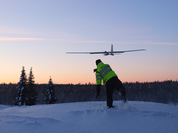
With its non-invasive, ground breaking surveying technology, Radai is bringing environmental exploration in the 21st Century. Radai is an innovative Finnish company specialized in drone based environmental and geophysical surveys, data analysis and specialist services. Company’s high-performance exploration systems can easily detect and determine the magnetic fields in the ground, thus giving more accurate data about underground resources. Its tailor made services are suitable for a wide variety of applications like mineral exploration, geological mapping, environmental monitoring and conductivity mapping.Radai’s technologyRadai’s technology consists of a high-performance magnetic survey system that is based on a fixed-wing drone with an electric engine. It can measure magnetic total field intensity and also the individual XYZ components of the magnetic field. XYZ components help data interpretation by reducing the ambiguity of the inverse solution. The aircraft operates at an altitude of 30-60 metres, with flight line spacing 20-50 metres. Under suitable conditions, the maximum flight time is almost three hours. As the flight speed is about 15-20 m/s, individual flights can be up to 230 km long. This method allows surveys up to 6 000 line-km to be completed in about 30 days. Weather conditions (temperature, daylight, moisture) will affect the operation efficiency. During the past three years Radai’s drones covered about 40 000 kilometres measuring earth’s magnetic field in Finland. That equals the circumference of Earth. The company’s record for conducting a survey in one single day is over one thousand line kilometers.Radai’s solution is highly customizable. Based on customer’s needs and specifications, the process can be adapted in order to get the best possible outcome. When a company needs a high resolution magnetic data, it contacts Radai. A meeting with one of the company's representatives will be scheduled as soon as possible. During the specification meeting, the project's requirements are evaluated and the best survey method and solution is found. From this point on, Radai’s experts get in charge: they will plan and execute the survey, collect data, process, model and interpret it. Survey’s results are going to be delivered under the form of a report and data set. The customer evaluates the data and, based on his geological needs, further surveying can be done until an accurate mapping of the targeted area is obtained. Company’s performance is fuelled by innovative mindsets, passion for exploring the boundaries of science and high level of expertise. Its employees are accomplished specialists from seven different high-tech fields: applied mathematics, data analysis and modelling, geophysics, usability and user experience research, software development and RC vehicles development. Seven members of Radai’s team have strong ties in research and development while two of them have PhD's (space physics and geophysics). There is no wonder why the company is involved in various scientific projects and collaborating with research institutes and universities around the world. Research, development and European projectsRadai is one of the key partners in the Horizon 2020 New Exploration Technologies (NEXT) and Horizon 2020 GoldenEye projects - which are large pan-European research consortiums that aims to develop new innovative solutions for novel sensitive exploration technologies and data analysis methods that are fast, cost-effective, environmentally safe and socially accepted.Radai’s main contribution consists of a novel electromagnetic (EM) survey system utilizing a 3-component EM receiver carried by a multicopter. The EM system provides information about the electrical properties (conductivity and permittivity) of the subsurface. The EM data, together with the magnetic field, provide essential information for geological mapping and mineral exploration. The technology developed in the NEXT project by Radai, Loop & Line and Geological Survey Of FInland was ranked by Innovation Radar -an European Commission initiative, as top innovation with major market potential in the future.Radai’s in-house developed technology offers notable benefits to sectors that are considered vital for European Union’s economy such as environmental monitoring and sustainable exploitation of resources. The use of unmanned aerial vehicles makes environmental and geophysical surveying not only environmentally friendly, but it also allows access to remote and difficult zones, thus offering more precise information about surveyed areas. Radai’s solution is faster and more cost effective than other surveying technologies. Besides that, the sensors developed by Radai’s experts are proved to give very accurate results.Using the brain power of its brilliant team, the company strives to offer the best possible solutions to its customers. Therefore, it is continuously improving existing technologies and developing new measurement methods. Radai is a firm with one step ahead mindset. Follow Radai on Linkedin and YouTube in order to get updates about the company's future achievements.www.radai.fi
Radai Ltd
Teknologiantie 18
90590 Oulu
e-mail: [email protected]
Tel: +358 45 1653443Artikkeli on julkaistu Teollisuusuutiset-lehdessä 4/2020.
Haluatko oman yrityksen esille tähän?